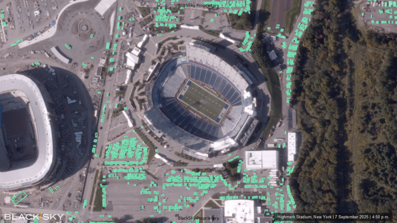
BlackSky and Iceye are partnering with AI-visualization experts Aechelon Technology and Niantic Spatial to create a digital twin of Earth.
The project, called Project Orbion, aims to create a massive geospatial model of the planet that can be regularly updated with fresh satellite data.
How Project Orbion Works
To make this possible, BlackSky will provide high-resolution imagery, while Iceye contributes radar data. All of it will be integrated into Skybeam, Aechelon’s powerful 3D global database.
“Our job is to make the data available for either human users or algorithms,” Nacho Sanz-Pastor, Aechelon co-founder and CEO, said during a Sept. 8 press briefing. “Machine-learning algorithms are hungry for current data. Frequent satellite observations allow Aechelon to provide those updates.”
For Project Orbion, BlackSky gives users access through its API. That means they can task satellites, pull already captured images, and use built-in analytics.
One of the main goals of the project is to bring together different sources of imagery and data into a single system, explained Scot Currie, BlackSky’s vice president of geospatial solutions.
Real-World Applications
This has real-world uses, from tracking wildfires to military targeting, where having accurate, up-to-date global models is essential. To support that, the partners are also creating standards for how geospatial data is shared and communicated, said Pekka Laurila, Iceye co-founder and chief strategy officer.
Pilot Project: 3D Scanning for the U.S. Coast Guard
Niantic and Aechelon also announced that the first test for Project Orbion will involve providing 3D scanning and simulation technology to the United States Coast Guard Aviation Training Center.
Aechelon’s flight simulator image generators will work with Niantic Spatial’s technology to perform tasks like scanning and evaluating helicopter landing zones.
“Aechelon has spent decades creating the most realistic synthetic environments for mission-critical training,” Sanz-Pastor said in a statement. “The challenge has always been keeping pace with changes in the physical world. Niantic Spatial’s technology plays a crucial role in addressing specific use cases, and when combined with our own AI-driven, world-wide multi-sensor baseline, it becomes a powerful solution.”


Leave a Reply